| Welcome to the CartONG Google application! The CartONG google application is a dynamic internet tool that you can use to view,download and edit information on the IDP operations in Uganda How to access to the interface ?
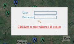
There are 2 options :
It is not necessary to be registered to access and download the information on the site. Just click on “click here to enter without edit options”
In order to participate in the elaboration of the Geodatabase and to have the possibility to edit, share, and to upload information for the humanitarian community. You will have the possibility to edit all information except information related to IDP camps, IDP sites, that is only managed by UNHCR/CartONG. If you are interested you can request a password from info@cartong.org. |
The map being wide, the display cannot be seen at once, the following are aids to help you navigate through the page to have an overview of the whole map depending on your area interest.
Description of the interface
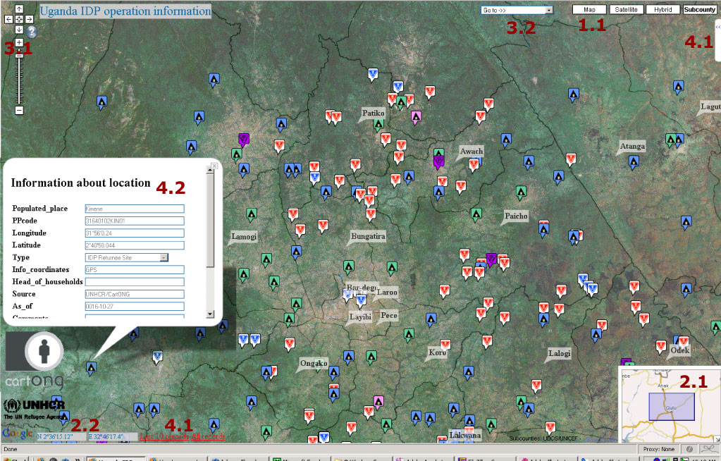
1 Quick step by step how to use it? (references are made with the print screen)
1.2 choosing the background: 4 options
· The lighter background but the quicker in terms of loading: the map.
· The satellite background. Offers the possibility to access to high resolution for some IDP camp. (Acet, Unyama…)
· The hybrid map will mix the information from the map (roads) and with the satellite background (it is the longest one to be loaded)
· The sub county map with the sub county boundaries. Note there is a limit of zooming when the subcounty layer is loaded
2 Where are you ?
2.1 The corner map allows you to locate in a wider environment. Could be minimized by clicking in the small arrows in the bottom right corner. You could pan your map with the corner map as well.
2.2 The cursor location in the bottom provides you the coordinates in Degrees Minutes Second...It will be the coordinates that you might read from your GPS if your GPS is configured in DMS. Quite useful to record immediately after your field visit a new Point of Interest (POI).
3.1 For non Google earth/Google maps users, the tool allows to pan, to zoom-in, zoom-out in the area of interest. Use the arrows or your hand to move, use the cursor to zoom on your point of interest.
The pan (arrow) that points to the right enables you to scroll to the right side of the page that displays the map.
The pan (arrow) that points to the left enables you to scroll to the left side of the page to display other section of the map.
The pan (arrow) that points up helps you scroll down the map and the pan (arrow) pointing down helps scroll the map up for a better view of none displayed sections of the map.
Just below the pans there appears a connection of a positive (+) and negative (-) signs,
These help you to zoom in and zoom out. Zoom in limits the view and zoom out give you a broader view.
3.2 Direct access to the subcounty of your choice. Use the drop down box menu and the map will be automatically centered in the middle of the subcounty
3.3 Search function. Type the string that you are looking for. Like "Kalongo", the information will be returned in a few seconds. It will search and locate the desired location on the map. The search tool is looking for all entries that start with the string entered and then will search in the middle of the word.
4 Accessing/editing information in the remote database
 4.1. Accessing to the latest information recorded
by the humanitarian community. It is difficult to know among all this information
when was recorded the latest information. CartONG choose to display directly
the latest Point of Interest (POI) added in the database.
4.1. Accessing to the latest information recorded
by the humanitarian community. It is difficult to know among all this information
when was recorded the latest information. CartONG choose to display directly
the latest Point of Interest (POI) added in the database.
Accessing and editing the categories. On the right you have a thumbnail with a left menu, click on the right thumbnail and have look on the item list. You have categories. These categories are non exhaustive.
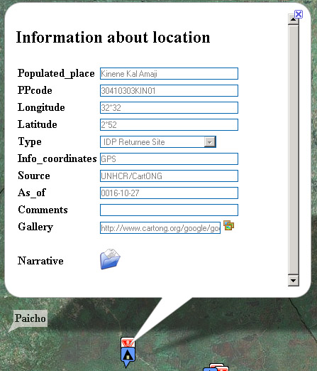
4.2 Accessing and editing to the attribute information: just click on the symbol. A pop-up will appear with the attribute table. To edit the map select the symbol, click once and an information box appears make the changes as necessary and save not to lose the new information.
4.3 If you would like to modify it for a quick update, just click on edit features and change the fields. Save it.
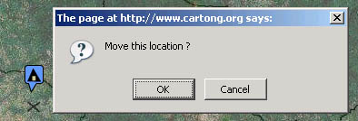
4.4 Moving a point: If you think that you have not put the symbol at the correct place, switch on the button radio of edit features you could drag and drop the symbol. The cross shadow of the pushpins displays the coordinates. If you are sure that you want to move the symbol click "ok". If you want to delete it, just click on cancel !
4.5 Creating a new item, just right click and the complete the fields, use the drop down box list to choose the type of information that you want to register. Finally save. Simple, isn't it?
5 Building a common database
When
you register information via the CartONG Google API, you are consolidating
a database. This database could be further used in a GIS application or a
web platform. Feel free to contact us info@cartong.org
if you want to download the database. The aim is also to build a common database
on the IDP sites and facilities in the returnee areas. If you are aware that
a new feature of interest (new populated place, schools ) exists but not recorded,
you could add, if you know position, (even if it is approximate, in
this case complete the appropriate field), and just complete the empty fields:
name of the sites, estimated populated place.
6 Sharing coordinates with GeoRSS.
You might be interested to insert
some of the coordinates in your GIS application on or your PAD. Use the GeoRSS
features to download the coordinates for a future use in the GIS application.
You could subscribe to the feeds in order to be aware of the latest Information.
![]() http://www.cartong.org/google/google_map/google_uga/inc/geoRSS.php
http://www.cartong.org/google/google_map/google_uga/inc/geoRSS.php
7 Sources
Content on this part of the website is made available thanks to participating agencies sharing their relevant logistic information.
Type of data that could be accessible. Point of interest about UXO,IDP Camp, villages, Boreholes, Schools. Sources: UNHCR, IOM, FAO, OCHA,WFP, CartONG, AVSI, NRC, ASB, ARC.
Projection Longitude Latitude/WGS 84. Coordinates are displayed in the map in Degree Minutes and Seconds,in the Info bull they are displayed in Decimal Degrees.
The data provided are under the responsibility of the organization that posted the information. CartONG is not responsible in case of misinformation.
The boundaries and names shown and the designations used on this map do not imply official endorsement or acceptance by the United Nations/CartONG.